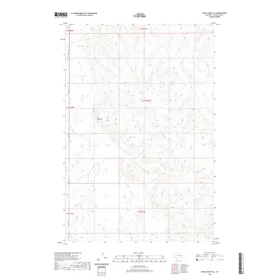
2020 Map of Horse Creek Hill
USGS Topo · Published 2020About this map
Horse Creek Hill rises as the central topographic feature of this Custer County landscape, where an intricate network of ephemeral drainages defines the local geography. The map captures a ranching and grazing environment dominated by major coulees and creek beds, including Muster Cr and Sand Cr in the north, and the W Fork Sand Cr further south. A single primary artery, Deadman Rd, skirts the western edge of the quadrangle, following the course of Horse Cr and Deadman Cr. This alignment suggests the traditional reliance on valley floors for transport through the broken terrain. Of particular interest to those tracing historical land use is the isolated Clevenger Spring in the eastern section, a critical water source in an area otherwise characterized by intermittent flows such as Alkali Cr and Thompson Cr.
Find a feature on this map
16 named features on this map. Tap any name to fly to it.
Don’t see what you’re looking for? This feature index may not catch every label — zoom into the map to look around manually.
Map Details
Editions of this 2020 Horse Creek Hill Map
This is the sole edition of this map. No revisions or reprints were ever made.
Other maps of this area

1953 · Miles City
USGS Topo · 1:250,000

1954 · Forsyth
USGS Topo · 1:250,000

1957 · Miles City
USGS Topo · 1:250,000

1957 · Forsyth
USGS Topo · 1:250,000

1958 · Miles City
USGS Topo · 1:250,000

1958 · Forsyth
USGS Topo · 1:250,000

1965 · Twin Buttes School
USGS Topo · 1:24,000

1965 · Morehouse Creek
USGS Topo · 1:24,000
1965 · Crow Rock SE
USGS Topo · 1:24,000

1969 · Horse Creek Hill
USGS Topo · 1:24,000