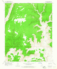
1964 Map of Horse Flat
USGS Topo · Published 1965About this map
Horse Flat and the surrounding high desert of Kane County are defined on this 1964 survey by the dramatic linear uplift of The Cockscomb. This geological feature slices through the western portion of the map, creating a distinct boundary between the Rush Beds Creek drainage and the complex canyon systems to the east. The landscape is marked by the Salt Lake Meridian, which serves as a primary surveying backbone for the region.
Find a feature on this map
14 named features on this map. Tap any name to fly to it.
Don’t see what you’re looking for? This feature index may not catch every label — zoom into the map to look around manually.
Map Details
Editions of this 1964 Horse Flat Map
2 editions found
Other maps of this area

1886 · Escalante
USGS Topo · 1:250,000

1922 · Upper Last Chance
USGS Topo · 1:63,360

1953 · Nipple Butte
USGS Topo · 1:62,500

1954 · Paria NW
USGS Topo · 1:24,000

1954 · Paria
USGS Topo · 1:62,500

1955 · The Cockscob SW
USGS Topo · 1:24,000

1956 · Escalante
USGS Topo · 1:250,000

1960 · Escalante
USGS Topo · 1:250,000

1964 · Horse Flat
USGS Topo · 1:24,000
1964 · Calico Peak
USGS Topo · 1:24,000