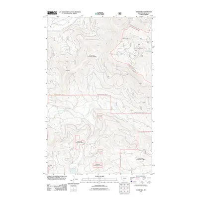
2011 Map of Horse Hill
USGS Topo · Published 2011About this map
Horse Hill Mine sits as a prominent industrial landmark on the slopes of Horse Hill, revealing the mineral extraction history of this Lincoln County landscape. The drainage network is dense and well-defined, with Sinclair Creek and Little Wolf Creek carving through the terrain towards larger waters like Wolf Creek. In the southern portion of the sheet, Island Lake and Island Creek mark a shift in the topography near Surprise Hill.
Find a feature on this map
18 named features on this map. Tap any name to fly to it.
Don’t see what you’re looking for? This feature index may not catch every label — zoom into the map to look around manually.
Map Details
Editions of this 2011 Horse Hill Map
This is the sole edition of this map. No revisions or reprints were ever made.
Other maps of this area

1920 · Jennings
USGS Topo · 1:125,000

1935 · Thompson Lakes
USGS Topo · 1:96,000

1942 · Thompson Lakes
USGS Topo · 1:125,000

1957 · Kalispell
USGS Topo · 1:250,000

1960 · Kalispell
USGS Topo · 1:250,000

1961 · Kalispell
USGS Topo · 1:250,000

1963 · Wolf Prairie
USGS Topo · 1:24,000

1963 · Warland Peak
USGS Topo · 1:24,000

1963 · Sylvia Lake
USGS Topo · 1:24,000
1963 · Bowen Lake
USGS Topo · 1:24,000