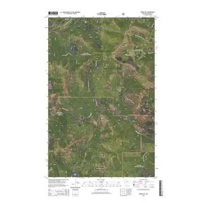
2014 Map of Horse Hill
USGS Topo · Published 2014About this map
Kootenai National Forest and Flathead National Forest converge in this high-elevation corner of Lincoln County, where the landscape is defined by the drainage networks of the Salish Mountains. The terrain is anchored by prominent summits including Sheppard Mtn, Tepee Mtn, and the namesake Horse Hill. To the southwest, Surprise Hill rises above the valley floor near Island Lake, a significant water feature fed by Island Cr. This area is a patchwork of forest management zones, including sections labeled KNF and Kootenai NF. Access to this back-country terrain is facilitated by a complex system of timber and fire roads, such as Little Wolf Creek Rd and several National Forest Development Roads. The hydrology is dominated by the headwaters of Wolf Cr, Little Wolf Cr, and Sinclair Cr, which carve deep drainages through the steep, timbered slopes of the northwestern Montana interior.
Find a feature on this map
25 named features on this map. Tap any name to fly to it.
Don’t see what you’re looking for? This feature index may not catch every label — zoom into the map to look around manually.
Map Details
Editions of this 2014 Horse Hill Map
This is the sole edition of this map. No revisions or reprints were ever made.
Other maps of this area

1920 · Jennings
USGS Topo · 1:125,000

1935 · Thompson Lakes
USGS Topo · 1:96,000

1942 · Thompson Lakes
USGS Topo · 1:125,000

1957 · Kalispell
USGS Topo · 1:250,000

1960 · Kalispell
USGS Topo · 1:250,000

1961 · Kalispell
USGS Topo · 1:250,000

1963 · Wolf Prairie
USGS Topo · 1:24,000

1963 · Warland Peak
USGS Topo · 1:24,000

1963 · Sylvia Lake
USGS Topo · 1:24,000
1963 · Bowen Lake
USGS Topo · 1:24,000