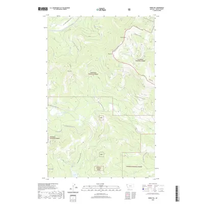
2020 Map of Horse Hill
USGS Topo · Published 2020About this map
The Flathead / Kootenai Divide runs through this section of Lincoln County, marking the boundary between the Flathead National Forest and Kootenai National Forest. This 2020 survey documents a landscape defined by industrial forest management and high-altitude terrain, where peaks like Sheppard Mtn and Tepee Mtn tower over a network of service roads. A clear indicator of the area's logistical history is the presence of Old Railroad Grade Rd, which follows a path likely established for timber extraction near Little Wolf Creek. In the southern portion of the quadrangle, Island Lake and Island Creek sit below Surprise Hill, providing a low-lying contrast to the northern summits of Horse Hill and Sanders Mtn. The map effectively illustrates the modern integration of historical transport corridors into the current Forest Development Road system.
Find a feature on this map
28 named features on this map. Tap any name to fly to it.
Don’t see what you’re looking for? This feature index may not catch every label — zoom into the map to look around manually.
Map Details
Editions of this 2020 Horse Hill Map
This is the sole edition of this map. No revisions or reprints were ever made.
Other maps of this area

1920 · Jennings
USGS Topo · 1:125,000

1935 · Thompson Lakes
USGS Topo · 1:96,000

1942 · Thompson Lakes
USGS Topo · 1:125,000

1957 · Kalispell
USGS Topo · 1:250,000

1960 · Kalispell
USGS Topo · 1:250,000

1961 · Kalispell
USGS Topo · 1:250,000

1963 · Wolf Prairie
USGS Topo · 1:24,000

1963 · Warland Peak
USGS Topo · 1:24,000

1963 · Sylvia Lake
USGS Topo · 1:24,000
1963 · Bowen Lake
USGS Topo · 1:24,000