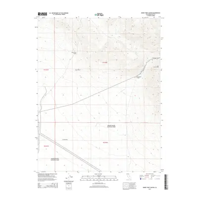
2015 Map of Horse Thief Canyon
USGS Topo · Published 2015About this map
Death Valley National Park encompasses a significant portion of this high-desert landscape, where the southern reaches of the Last Chance Range meet the arid floor of Eureka Valley. The terrain is defined by dramatic elevation changes, notably within the steep-walled Horse Thief Canyon and the winding Cucomungo Canyon. Water, while scarce, has shaped the geology, leaving behind the dendritic patterns of Willow Wash and the ephemeral Willow Cr. This 2015 record illustrates the vastness of the Mojave Desert and the precise management boundaries of federal lands, including the Public Land Survey System grids for Townships 7 and 8 South. The lack of modern development emphasizes the role of these protected lands as an preserved arid wilderness, highlighting the natural drainages that have served as historical corridors through the mountains.
Find a feature on this map
13 named features on this map. Tap any name to fly to it.
Don’t see what you’re looking for? This feature index may not catch every label — zoom into the map to look around manually.
Map Details
Editions of this 2015 Horse Thief Canyon Map
This is the sole edition of this map. No revisions or reprints were ever made.
Other maps of this area

1908 · Lida
USGS Topo · 1:250,000

1913 · Lida
USGS Topo · 1:250,000

1954 · Goldfield
USGS Topo · 1:250,000

1955 · Goldfield
USGS Topo · 1:250,000

1957 · Magruder Mtn
USGS Topo · 1:62,500

1958 · Goldfield
USGS Topo · 1:250,000

1958 · Last Chance Range
USGS Topo · 1:62,500

1958 · Soldier Pass
USGS Topo · 1:62,500
1958 · Waucoba Spring
USGS Topo · 1:62,500

1962 · Goldfield
USGS Topo · 1:250,000