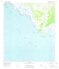
1954 Map of Horseshoe Beach
USGS Topo · Published 1975About this map
Horseshoe Beach centers this mid-century coastal survey, situated on a low-lying peninsula where the marshy Big Bend coastline meets the Gulf of Mexico. The landscape is defined by a intricate network of tidal waterways, including Whackup Creek, Boggy Creek, and Tripod Creek, which snake through the salt marshes towards Horseshoe Cove. An Old Railroad Grade cutting through the interior suggests the remnants of earlier logging or industrial transit lines that once serviced this isolated stretch of Dixie County.
Find a feature on this map
21 named features on this map. Tap any name to fly to it.
Don’t see what you’re looking for? This feature index may not catch every label — zoom into the map to look around manually.
Map Details
Editions of this 1954 Horseshoe Beach Map
3 editions found
Other maps of this area

1954 · Steinhatchee SW
USGS Topo · 1:24,000

1954 · Steinhatchee SE
USGS Topo · 1:24,000

1954 · Cross City SW
USGS Topo · 1:24,000

1954 · Horseshoe Beach
USGS Topo · 1:24,000

1954 · Suwannee
USGS Topo · 1:24,000

1954 · Gainesville
USGS Topo · 1:250,000

1955 · Shired Island
USGS Topo · 1:24,000

1958 · Gainesville
USGS Topo · 1:250,000

1959 · Gainesville
USGS Topo · 1:250,000

1978 · Cedar Keys
USGS Topo · 1:100,000