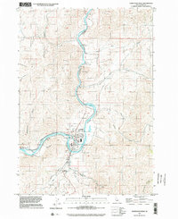
1998 Map of Horseshoe Bend
USGS Topo · Published 2002About this map
The Payette River carves a dramatic oxbow through this Boise County landscape, anchoring the settlement of Horseshoe Bend. This late 1990s documentation reveals a community shaped by water and industry, where the Power Canal feeds a Powerhouse and a local Millpond sits near the river's bend. The terrain is defined by steep draws like Peterson Gulch and Wakefield Gulch, rising toward the heights of Mount Maria. Historic footprints remain visible through the Pioneer Cemetery and the northern siding at Gardena. The presence of a Runaway Truck Ramp on Horseshoe Bend Road speaks to the challenging local topography that travelers and residents navigated daily. From the secluded Jerusalem Valley to the junctions of Shafer Creek, the map details a rural Idaho corridor transitioning into the modern era while maintaining its established timber and power roots.
Find a feature on this map
38 named features on this map. Tap any name to fly to it.
Don’t see what you’re looking for? This feature index may not catch every label — zoom into the map to look around manually.
Map Details
Editions of this 1998 Horseshoe Bend Map
This is the sole edition of this map. No revisions or reprints were ever made.
Other maps of this area

1892 · Boise
USGS Topo · 1:125,000

1894 · Squaw Creek
USGS Topo · 1:125,000

1897 · Boise
USGS Topo · 1:125,000

1953 · Banks
USGS Topo · 1:62,500

1953 · Montour
USGS Topo · 1:62,500

1955 · Baker
USGS Topo · 1:250,000

1955 · Boise
USGS Topo · 1:250,000

1957 · Cartwright Canyon
USGS Topo · 1:24,000

1957 · Horseshoe Bend
USGS Topo · 1:24,000
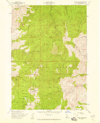
1957 · Shafer Butte
USGS Topo · 1:24,000