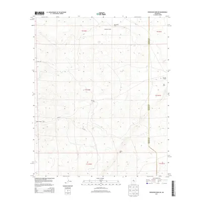
2013 Map of Horseshoe Bend NW
USGS Topo · Published 2013About this map
Elevenmile Ranch and Riley Ranch sit as solitary points of habitation within this expansive stretch of the High Plains along the border of Lincoln and Chaves Counties. The landscape is defined by its drainage patterns, most notably the wide paths of Blackwater Draw and Big Draw which cut across the eastern sections. These geographical features, along with named relief like Border Hill and Deadman Canyon, underscore the isolated ranching character of the region. Local travel is facilitated by a network of rural routes including Co Road E034 and Co Road E035, which provide the primary access to these remote operations in the early 21st century.
Find a feature on this map
18 named features on this map. Tap any name to fly to it.
Don’t see what you’re looking for? This feature index may not catch every label — zoom into the map to look around manually.
Map Details
Editions of this 2013 Horseshoe Bend NW Map
This is the sole edition of this map. No revisions or reprints were ever made.
Other maps of this area

1936 · Arabela
USGS Topo · 1:48,000

1942 · Arabela
USGS Topo · 1:62,500

1955 · Roswell
USGS Topo · 1:250,000

1956 · Diamond A Ranch
USGS Topo · 1:24,000

1958 · Roswell
USGS Topo · 1:250,000

1959 · Diamond A Ranch
USGS Topo · 1:24,000

1961 · Tinnie
USGS Topo · 1:62,500

1962 · Roswell
USGS Topo · 1:250,000

1962 · Horseshoe Bend
USGS Topo · 1:62,500
1967 · White Flat SE
USGS Topo · 1:24,000