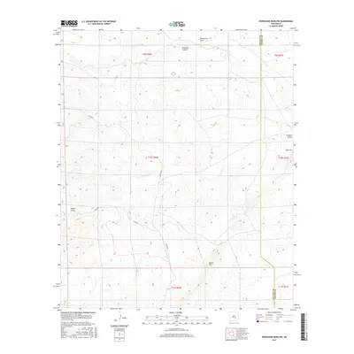
2017 Map of Horseshoe Bend NW
USGS Topo · Published 2017About this map
Border Hill stands as a prominent landmark in this high desert landscape along the border of Chaves and Lincoln counties. This 2017 survey documents an arid region defined by its complex network of seasonal drainage features, including the broad depressions of Blackwater Draw and Big Draw. The terrain is deeply incised by multiple canyons, such as Deadman Canyon in the north and Coyote Canyon to the southwest, illustrating the erosional patterns of the Pecos Valley watershed. Rural access is maintained through a grid of section-line roads, notably Co Rd E034 and Co Rd E035, which navigate the elevation changes near Tecolote Canyon. The map provides a precise look at the Public Land Survey System township and range boundaries that organized this part of New Mexico, showing how ranching infrastructure and local transit follow these historic geometric lines.
Find a feature on this map
16 named features on this map. Tap any name to fly to it.
Don’t see what you’re looking for? This feature index may not catch every label — zoom into the map to look around manually.
Map Details
Editions of this 2017 Horseshoe Bend NW Map
This is the sole edition of this map. No revisions or reprints were ever made.
Other maps of this area

1936 · Arabela
USGS Topo · 1:48,000

1942 · Arabela
USGS Topo · 1:62,500

1955 · Roswell
USGS Topo · 1:250,000

1956 · Diamond A Ranch
USGS Topo · 1:24,000

1958 · Roswell
USGS Topo · 1:250,000

1959 · Diamond A Ranch
USGS Topo · 1:24,000

1961 · Tinnie
USGS Topo · 1:62,500

1962 · Roswell
USGS Topo · 1:250,000

1962 · Horseshoe Bend
USGS Topo · 1:62,500
1967 · White Flat SE
USGS Topo · 1:24,000