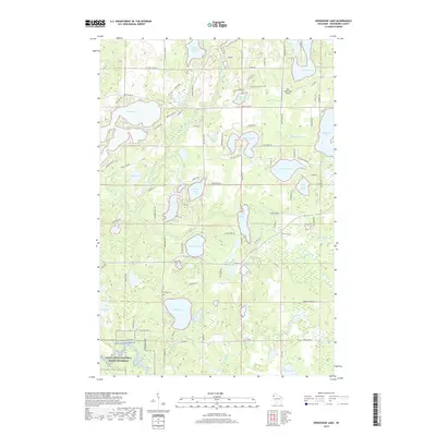
2019 Map of Horseshoe Lake
USGS Topo · Published 2019About this map
Lake Nancy and Gilmore Lake anchor a dense glacial landscape in Washburn County, characterized by a complex network of kettle lakes and meandering waterways. The southern reaches are defined by the Saint Croix National Scenic Riverway and the St. Croix Wild and Scenic River, where the Totagatic River contributes to a protected riparian corridor. Settlement is sparse, linked by rural routes like Nancy Lake Rd and Co Hwy I. Local heritage is preserved at the Chicog Cem, while the Ben Sutherland Airport serves as a small aviation landmark near the northern lakes. The map illustrates a region where water dominates the geography, from the larger expanses of Horseshoe Lake and Matthews Lake to the smaller basins of West Wilcox Lake and East Wilcox Lake. This 2019 survey documents a landscape focused on conservation and quiet residential pockets centered on the shorelines.
Find a feature on this map
95 named features on this map. Tap any name to fly to it.
Don’t see what you’re looking for? This feature index may not catch every label — zoom into the map to look around manually.
Map Details
Editions of this 2019 Horseshoe Lake Map
This is the sole edition of this map. No revisions or reprints were ever made.
Other maps of this area

1947 · Minong
USGS Topo · 1:48,000

1948 · Spooner
USGS Topo · 1:48,000

1949 · Hertel
USGS Topo · 1:48,000

1949 · Minong
USGS Topo · 1:48,000

1949 · Webb Lake
USGS Topo · 1:48,000

1949 · Spooner
USGS Topo · 1:48,000

1953 · Ashland
USGS Topo · 1:250,000

1953 · Duluth
USGS Topo · 1:250,000

1953 · Rice Lake
USGS Topo · 1:250,000

1953 · Stillwater
USGS Topo · 1:250,000