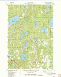
1982 Map of Horseshoe Lake
USGS Topo · Published 1982About this map
The St Croix National Scenic Riverway anchors the southwestern corner of this survey, where the Namekagon River flows through Washburn County. This glacial landscape is defined by an intricate network of waterways, including the prominent Minong Flowage and its associated Powerplant in the north. The area shows a transition from dense woodland and wetlands to recreational lakeside development, particularly around Nancy Lake, Chicog Lake, and Matthews Lake. Local transit is marked by historical routes like the St Croix Trail and specialized facilities such as the Sutherland Landing Strip. Small settlements and landings like Menah and Byrkits Landing provide evidence of early river-and-rail era connectivity near the Totagatic River.
Find a feature on this map
49 named features on this map. Tap any name to fly to it.
Don’t see what you’re looking for? This feature index may not catch every label — zoom into the map to look around manually.
Map Details
Editions of this 1982 Horseshoe Lake Map
This is the sole edition of this map. No revisions or reprints were ever made.
Other maps of this area

1947 · Minong
USGS Topo · 1:48,000

1948 · Spooner
USGS Topo · 1:48,000

1949 · Hertel
USGS Topo · 1:48,000

1949 · Minong
USGS Topo · 1:48,000

1949 · Webb Lake
USGS Topo · 1:48,000

1949 · Spooner
USGS Topo · 1:48,000

1953 · Ashland
USGS Topo · 1:250,000

1953 · Duluth
USGS Topo · 1:250,000

1953 · Rice Lake
USGS Topo · 1:250,000

1953 · Stillwater
USGS Topo · 1:250,000