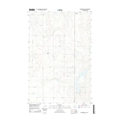
2014 Map of Horseshoe Valley
USGS Topo · Published 2014About this map
Horseshoe Valley defines this portion of McLean County, where the undulating terrain is punctuated by numerous small potholes and basins characteristic of the region's glacial legacy. The most prominent water body is Crooked Lake, which stretches through the eastern and southeastern sections of the map. The landscape is organized by a rigid grid of rural roads, including 15th Ave NW and 20th St NW, which facilitate access across the open plains. This 2014 survey documents the modern layout of these section-line roads and the persistent natural drainage patterns that have shaped land use in this part of North Dakota for generations.
Find a feature on this map
21 named features on this map. Tap any name to fly to it.
Don’t see what you’re looking for? This feature index may not catch every label — zoom into the map to look around manually.
Map Details
Editions of this 2014 Horseshoe Valley Map
This is the sole edition of this map. No revisions or reprints were ever made.
Other maps of this area

1929 · Coleharbor
USGS Topo · 1:62,500

1929 · Benedict
USGS Topo · 1:62,500

1929 · Kongsberg
USGS Topo · 1:62,500

1947 · Turtle Lake
USGS Topo · 1:62,500

1954 · McClusky
USGS Topo · 1:250,000

1958 · McClusky
USGS Topo · 1:250,000

1961 · Turtle Lake
USGS Topo · 1:24,000

1961 · Lake Nettie
USGS Topo · 1:24,000
1961 · Peterson Lake
USGS Topo · 1:24,000

1974 · Benedict SE
USGS Topo · 1:24,000