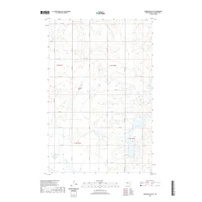
2020 Map of Horseshoe Valley
USGS Topo · Published 2020About this map
Horseshoe Valley defines the central terrain of this McLean County landscape, where the prairie is etched with a network of section-line roads and glacial depressions. The hydrology is dominated by Crooked Lake in the southeast, surrounded by numerous unnamed wetlands and seasonal basins typical of the North Dakota pothole region. This 2020 survey reveals a highly organized rural infrastructure, where transportation is dictated by a strict grid of avenues and streets, such as 19th Ave NW and 21st St NW. The map illustrates the persistent structure of the Public Land Survey System, with township boundaries like t149n r80w clearly marked. While the area is largely devoid of concentrated settlements, the density of county routes including Co Hwy 25 and Co Hwy 8 indicates the ongoing importance of this agricultural corridor in the early twenty-first century.
Find a feature on this map
24 named features on this map. Tap any name to fly to it.
Don’t see what you’re looking for? This feature index may not catch every label — zoom into the map to look around manually.
Map Details
Editions of this 2020 Horseshoe Valley Map
This is the sole edition of this map. No revisions or reprints were ever made.
Other maps of this area

1929 · Coleharbor
USGS Topo · 1:62,500

1929 · Benedict
USGS Topo · 1:62,500

1929 · Kongsberg
USGS Topo · 1:62,500

1947 · Turtle Lake
USGS Topo · 1:62,500

1954 · McClusky
USGS Topo · 1:250,000

1958 · McClusky
USGS Topo · 1:250,000

1961 · Turtle Lake
USGS Topo · 1:24,000

1961 · Lake Nettie
USGS Topo · 1:24,000
1961 · Peterson Lake
USGS Topo · 1:24,000

1974 · Benedict SE
USGS Topo · 1:24,000