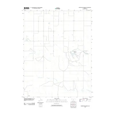
2009 Map of Horsethief Draw NE
USGS Topo · Published 2009About this map
North Fork Smoky Hill River and its surrounding drainage systems define this section of the High Plains, where the water table and surface flow dictate the layout of the land. The landscape is marked by the Sherman County State Lake Dam, a significant local hydrological modification within the watershed. This 2009 survey reveals the precision of the modern section-line road network, including routes such as Co RD 54 and Co RD 52, which provide access to the expansive agricultural plots and ranchlands. In the southwestern corner, the Fairview Cemetery stands as a quiet focal point for local genealogy and history, situated near Co RD 12. Further south, the meandering path of North Fork Lake Creek cuts through the territory, illustrating the natural watercourses that have shaped the rural development of Wallace and Sherman counties.
Find a feature on this map
15 named features on this map. Tap any name to fly to it.
Don’t see what you’re looking for? This feature index may not catch every label — zoom into the map to look around manually.
Map Details
Editions of this 2009 Horsethief Draw NE Map
This is the sole edition of this map. No revisions or reprints were ever made.
Other maps of this area

1954 · Goodland
USGS Topo · 1:250,000

1956 · Goodland
USGS Topo · 1:250,000

1957 · Goodland
USGS Topo · 1:250,000

1959 · Harris Draw
USGS Topo · 1:62,500

1959 · Horsethief Draw
USGS Topo · 1:62,500

1966 · Goodland
USGS Topo · 1:24,000

1966 · Ruleton
USGS Topo · 1:24,000
1966 · Ruleton SE
USGS Topo · 1:24,000
1979 · Horsethief Draw NW
USGS Topo · 1:24,000
1979 · Horsethief Draw
USGS Topo · 1:24,000