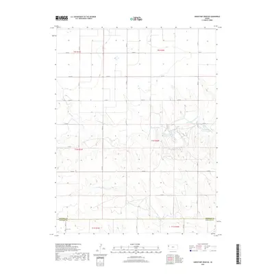
2018 Map of Horsethief Draw NE
USGS Topo · Published 2018About this map
North Fork Smoky Hill River and its tributaries carve a distinct path through the High Plains along the border of Sherman and Wallace counties. This landscape, dominated by wide drainage patterns and intermittent watercourses like Sandy Creek and North Fork Lake Creek, reflects the hydraulic character of the region. The map shows a transition from the rolling northern topography down toward the southern boundary at Fairview Cemetery. A notable concentration of water resources is found at Sherman County State Lake, which sits as a vital oasis in this semi-arid environment. The geometric grid of county roads, including County Road 57 and County Road 12, marks the systematic division of agricultural land that defines the western Kansas prairie during this era of modern land management.
Find a feature on this map
24 named features on this map. Tap any name to fly to it.
Don’t see what you’re looking for? This feature index may not catch every label — zoom into the map to look around manually.
Map Details
Editions of this 2018 Horsethief Draw NE Map
This is the sole edition of this map. No revisions or reprints were ever made.
Other maps of this area

1954 · Goodland
USGS Topo · 1:250,000

1956 · Goodland
USGS Topo · 1:250,000

1957 · Goodland
USGS Topo · 1:250,000

1959 · Harris Draw
USGS Topo · 1:62,500

1959 · Horsethief Draw
USGS Topo · 1:62,500

1966 · Goodland
USGS Topo · 1:24,000

1966 · Ruleton
USGS Topo · 1:24,000
1966 · Ruleton SE
USGS Topo · 1:24,000
1979 · Horsethief Draw NW
USGS Topo · 1:24,000
1979 · Horsethief Draw
USGS Topo · 1:24,000