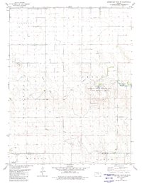
1979 Map of Horsethief Draw NE
USGS Topo · Published 1980About this map
The North Fork Smoky Hill River and Smoky Hill River dominate this High Plains landscape in Sherman County, Kansas. The confluence of these waterways and the drainage from Sandy Creek define the local topography, which features a mix of river bottomland and upland plains divided by township boundaries like Morton, North, and Lincoln. This 1970s survey captures a transition toward recreational and commemorative land use, evidenced by the large Sherman State Fishing Lake and Wildlife Area and the Soldiers Memorial County Park. Genealogy and local history researchers will find the Fairview Cem at the southern edge of the map, while industrial activity is represented by a small Sandpit near the river fork. The map also documents a network of rural water wells and section roads that supported the agricultural operations of the era.
Find a feature on this map
14 named features on this map. Tap any name to fly to it.
Don’t see what you’re looking for? This feature index may not catch every label — zoom into the map to look around manually.
Map Details
Editions of this 1979 Horsethief Draw NE Map
This is the sole edition of this map. No revisions or reprints were ever made.
Other maps of this area

1954 · Goodland
USGS Topo · 1:250,000

1956 · Goodland
USGS Topo · 1:250,000

1957 · Goodland
USGS Topo · 1:250,000

1959 · Harris Draw
USGS Topo · 1:62,500

1959 · Horsethief Draw
USGS Topo · 1:62,500

1966 · Goodland
USGS Topo · 1:24,000

1966 · Ruleton
USGS Topo · 1:24,000
1966 · Ruleton SE
USGS Topo · 1:24,000
1979 · Horsethief Draw NW
USGS Topo · 1:24,000
1979 · Horsethief Draw
USGS Topo · 1:24,000