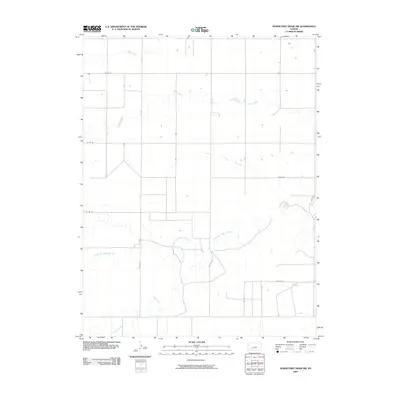
2009 Map of Horsethief Draw NW
USGS Topo · Published 2009About this map
The North Fork Smoky Hill River meanders across this rural section of Wallace County, defining a landscape primarily shaped by its drainage systems and a rigid grid of local transport. Water is the central feature of this western Kansas terrain, with the Sandy Creek and Sappa Creek systems cutting through the northern half of the quadrangle while Turtle Creek enters from the southwest. The human imprint on the land is represented by a network of numbered county roads, including Co Rd 57 and Co Rd 53, which delineate the section lines. This 2009 survey by the U.S. Geological Survey illustrates the intersection of these vital waterways with a highly organized agricultural infrastructure, showing several isolated structures and homesteads situated near the riverbanks and along the arterial routes like Co Rd 11 and Co Rd 8.
Find a feature on this map
13 named features on this map. Tap any name to fly to it.
Don’t see what you’re looking for? This feature index may not catch every label — zoom into the map to look around manually.
Map Details
Editions of this 2009 Horsethief Draw NW Map
This is the sole edition of this map. No revisions or reprints were ever made.
Other maps of this area

1954 · Limon
USGS Topo · 1:250,000

1954 · Goodland
USGS Topo · 1:250,000

1956 · Goodland
USGS Topo · 1:250,000

1957 · Limon
USGS Topo · 1:250,000

1957 · Goodland
USGS Topo · 1:250,000

1958 · Limon
USGS Topo · 1:250,000

1959 · Horsethief Draw
USGS Topo · 1:62,500

1966 · Ruleton
USGS Topo · 1:24,000
1966 · Ruleton SE
USGS Topo · 1:24,000
1969 · Mount Sunflower
USGS Topo · 1:24,000