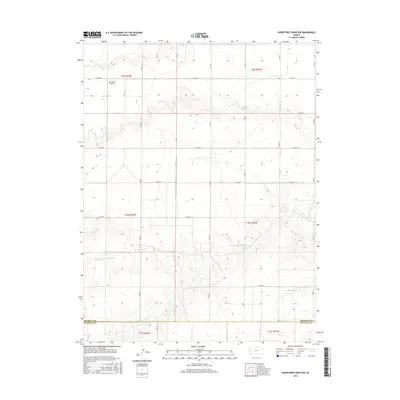
2015 Map of Horsethief Draw NW
USGS Topo · Published 2015About this map
The N Fork Smoky Hill River meanders through the heart of this High Plains landscape, marking a significant hydrologic transition on the border of Sherman and Wallace counties. The terrain is defined by a series of drainages, including Sappa Cr and Sandy Cr, which carve into the upland plateau. Agricultural land management is evident through the established grid of county roads, such as Co RD 57 and Co RD 51, which facilitate access to remote homesteads and operations. A notable localized landmark is the Hall Farms Airport, reflecting the importance of private aviation for transport and crop management in this sparsely populated region of western Kansas. Further south, N Fork Lake Cr and Turtle Cr underscore the complex network of seasonal and perennial waterways that have historically dictated the placement of ranching infrastructure and rural boundaries.
Find a feature on this map
24 named features on this map. Tap any name to fly to it.
Don’t see what you’re looking for? This feature index may not catch every label — zoom into the map to look around manually.
Map Details
Editions of this 2015 Horsethief Draw NW Map
This is the sole edition of this map. No revisions or reprints were ever made.
Other maps of this area

1954 · Limon
USGS Topo · 1:250,000

1954 · Goodland
USGS Topo · 1:250,000

1956 · Goodland
USGS Topo · 1:250,000

1957 · Limon
USGS Topo · 1:250,000

1957 · Goodland
USGS Topo · 1:250,000

1958 · Limon
USGS Topo · 1:250,000

1959 · Horsethief Draw
USGS Topo · 1:62,500

1966 · Ruleton
USGS Topo · 1:24,000
1966 · Ruleton SE
USGS Topo · 1:24,000
1969 · Mount Sunflower
USGS Topo · 1:24,000