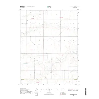
2018 Map of Horsethief Draw NW
USGS Topo · Published 2018About this map
North Fork Smoky Hill River and Sappa Creek carve through the High Plains landscape of Western Kansas, defining a terrain shaped by seasonal drainage and agricultural layout. This region along the Sherman and Wallace County line reflects a deeply structured rural environment, where section lines are strictly followed by a grid of local roads like County Road 57 and County Road 51. The presence of the Hall Farms Airport in the northwest corner highlights the importance of private aviation for large-scale ranching and farming operations in this remote area. Intermittent waterways such as Sandy Creek and Turtle Creek cross the townships of Township 10 South, Range 41 West and Range 42 West, tracing the natural hydrology that governs land use in this part of the state.
Find a feature on this map
19 named features on this map. Tap any name to fly to it.
Don’t see what you’re looking for? This feature index may not catch every label — zoom into the map to look around manually.
Map Details
Editions of this 2018 Horsethief Draw NW Map
This is the sole edition of this map. No revisions or reprints were ever made.
Other maps of this area

1954 · Limon
USGS Topo · 1:250,000

1954 · Goodland
USGS Topo · 1:250,000

1956 · Goodland
USGS Topo · 1:250,000

1957 · Limon
USGS Topo · 1:250,000

1957 · Goodland
USGS Topo · 1:250,000

1958 · Limon
USGS Topo · 1:250,000

1959 · Horsethief Draw
USGS Topo · 1:62,500

1966 · Ruleton
USGS Topo · 1:24,000
1966 · Ruleton SE
USGS Topo · 1:24,000
1969 · Mount Sunflower
USGS Topo · 1:24,000