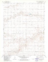
1979 Map of Horsethief Draw NW
USGS Topo · Published 1980About this map
North Fork Smoky Hill River meanders across this High Plains landscape, marking a terrain defined by seasonal drainage and industrial extraction. The 1979 survey captures the borderlands of Sherman and Wallace counties, where the high tablelands are dissected by Sappa Creek and Sandy Creek. Local resource extraction is evident through scattered Gravel Pits and a Sandpit, while agricultural infrastructure is represented by numerous wells and a solitary Substation. In the southeastern corner, Turtle Creek Lake and Turtle Creek provide a localized focus for water management. The survey also notes technical landmarks such as a Drill Hole, illustrating the subsurface exploration occurring alongside traditional ranching and farming in this western Kansas corridor.
Find a feature on this map
16 named features on this map. Tap any name to fly to it.
Don’t see what you’re looking for? This feature index may not catch every label — zoom into the map to look around manually.
Map Details
Editions of this 1979 Horsethief Draw NW Map
This is the sole edition of this map. No revisions or reprints were ever made.
Other maps of this area

1954 · Limon
USGS Topo · 1:250,000

1954 · Goodland
USGS Topo · 1:250,000

1956 · Goodland
USGS Topo · 1:250,000

1957 · Limon
USGS Topo · 1:250,000

1957 · Goodland
USGS Topo · 1:250,000

1958 · Limon
USGS Topo · 1:250,000

1959 · Horsethief Draw
USGS Topo · 1:62,500

1966 · Ruleton
USGS Topo · 1:24,000
1966 · Ruleton SE
USGS Topo · 1:24,000
1969 · Mount Sunflower
USGS Topo · 1:24,000