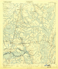
1918 Map of Hortense
USGS Topo · Published 1918About this map
The Satilla River and its meandering tributaries dominate this 1917 survey of southeast Georgia, where the winding waterway defines the southern boundary between Wayne and Pierce counties. Small communities like Hortense and Trudie are connected by a network of logging and transport routes, including the Atlantic Coast Line and the Birmingham and Atlantic railroads. The landscape is heavily characterized by its wetlands, notably the expansive Penholoway Bay and Duck Pond Swamp.
Find a feature on this map
45 named features on this map. Tap any name to fly to it.
Don’t see what you’re looking for? This feature index may not catch every label — zoom into the map to look around manually.
Map Details
Editions of this 1918 Hortense Map
2 editions found
Other maps of this area

1917 · Nahunta
USGS Topo · 1:62,500

1918 · Jesup
USGS Topo · 1:62,500

1918 · Hortense
USGS Topo · 1:62,500

1918 · Everett City
USGS Topo · 1:62,500

1918 · Nahunta
USGS Topo · 1:62,500

1918 · Bladen
USGS Topo · 1:62,500

1920 · Everett City
USGS Topo · 1:62,500

1939 · Bladen
USGS Topo · 1:62,500

1943 · Ludowici
USGS Topo · 1:62,500

1943 · Jesup
USGS Topo · 1:62,500