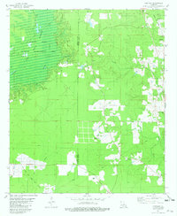
1981 Map of Hortman
USGS Topo · Published 1982About this map
Bodcau State Wildlife Management Area dominates the northwestern portion of this 1980s survey, where the Bodcau Reservoir and Bayou Bodcau define the local hydrology. The landscape is a mix of conservation land and active industry, notably the Bellevue Oil and Gas Field in the southwest and several pipelines crossing the parish line. The eastern corridor follows the Louisiana and Arkansas rail line, which passes through the small community of Hortman. Rural life is centered around several family and community landmarks, such as Bright Star Ch and the Whispering Pines Cem. The boundary between Bossier Parish and Webster Parish bisects the quadrangle, illustrating the connectivity between these two districts through a network of creeks like Brushy Creek and Sausman Creek.
Find a feature on this map
28 named features on this map. Tap any name to fly to it.
Don’t see what you’re looking for? This feature index may not catch every label — zoom into the map to look around manually.
Map Details
Editions of this 1981 Hortman Map
2 editions found
Other maps of this area

1922 · Sarepta
USGS Topo · 1:62,500

1924 · Sarepta
USGS Topo · 1:62,500

1932 · Bossier SE
USGS Topo · 1:31,680

1932 · Bossier NE
USGS Topo · 1:31,680

1947 · Minden
USGS Topo · 1:62,500

1948 · Bossier City
USGS Topo · 1:62,500

1949 · Minden
USGS Topo · 1:62,500

1950 · Plain Dealing SE
USGS Topo · 1:31,680

1955 · Shreveport
USGS Topo · 1:250,000
1955 · Bossier City
USGS Topo · 1:62,500