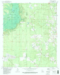
1981 Map of Hortman
USGS Topo · Published 1982About this map
The Bossier Parish Webster Parish line bisects this 1981 survey of the Louisiana bayou country, where the landscape is defined by the expansive Bodcau Reservoir and the Bodcau State Wildlife Management Area. The western half of the map is dominated by the winding path of Bayou Bodcau and the terrain of Coach Hole, while the southern reaches show the industrial footprint of the Bellevue Oil and Gas Field. A network of small rural congregations and family burial grounds, such as Bright Star Ch, Growing Valley Cem, and Whispering Pines Cem, anchor the scattered settlement of Hortman. The presence of several Pipeline corridors and a Gravel Pit illustrates the intersection of natural conservation areas with the region's extraction-based economy during the late twentieth century.
Find a feature on this map
27 named features on this map. Tap any name to fly to it.
Don’t see what you’re looking for? This feature index may not catch every label — zoom into the map to look around manually.
Map Details
Editions of this 1981 Hortman Map
2 editions found
Other maps of this area

1922 · Sarepta
USGS Topo · 1:62,500

1924 · Sarepta
USGS Topo · 1:62,500

1932 · Bossier SE
USGS Topo · 1:31,680

1932 · Bossier NE
USGS Topo · 1:31,680

1947 · Minden
USGS Topo · 1:62,500

1948 · Bossier City
USGS Topo · 1:62,500

1949 · Minden
USGS Topo · 1:62,500

1950 · Plain Dealing SE
USGS Topo · 1:31,680

1955 · Shreveport
USGS Topo · 1:250,000
1955 · Bossier City
USGS Topo · 1:62,500