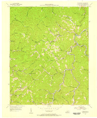
1954 Map of Hoskinston
USGS Topo · Published 1956About this map
Hoskinston and the surrounding Leslie County hollows are defined by a network of rural schools and mountain waterways in the mid-1950s. The settlement pattern follows the steep topography, with homes and community buildings concentrated along narrow valley floors such as those carved by Beech Fork and the Middle Fork. Educational life was highly localized, evidenced by the numerous small schoolhouses like Upper Trace Branch Sch and Upper Grassy Branch Sch that served remote populations before later consolidation. Along the eastern ridge, the Beech Fork Lookout Tower stands as a sentinel over the heavily wooded landscape. The map also records several small community centers, including Stinnett, where the Stinnett High Sch was located, and the village of Asher. This survey captures the traditional Appalachian life of the Cumberland Plateau just as road improvements began to change the character of these isolated mountain branches.
Find a feature on this map
68 named features on this map. Tap any name to fly to it.
Don’t see what you’re looking for? This feature index may not catch every label — zoom into the map to look around manually.
Map Details
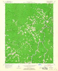
Editions of this 1954 Hoskinston Map
2 editions found
Other maps of this area

1886 · Cumberland Gap
USGS Topo · 1:125,000

1887 · Jonesville
USGS Topo · 1:125,000

1888 · Cumberland Gap
USGS Topo · 1:125,000

1891 · Manchester
USGS Topo · 1:125,000

1891 · Cumberland Gap
USGS Topo · 1:125,000

1891 · Hazard
USGS Topo · 1:125,000

1891 · Jonesville
USGS Topo · 1:125,000
1903 · Harlan
USGS Topo · 1:48,000

1903 · Pineville
USGS Topo · 1:48,000
1916 · Harlan
USGS Topo · 1:48,000