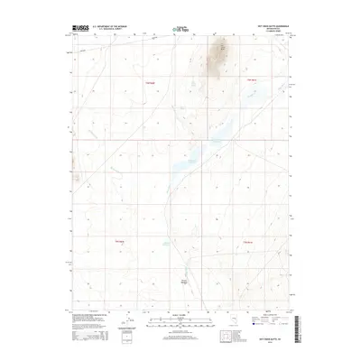
2014 Map of Hot Creek Butte
USGS Topo · Published 2014About this map
Hot Creek Butte rises as a prominent landmark over a desert landscape defined by a critical network of water sources in this 2014 survey. The topography is shaped by the White River and Moon River, which feed into several man-made catchments including Hay Meadow Reservoir, Tule Field Reservoir, and Whipple Reservoir. These features, along with Moon River Spring and Camp Spring, illustrate the essential role of water management in this arid region of Nye County. The map shows a clear division of the land into townships, including t6n r60e and t5n r61e, while the Sunnyside road provides the primary transit corridor. Murphy Meadows and Big Spring Wash further define the natural drainage patterns that have historically dictated the use of this high-desert terrain.
Find a feature on this map
15 named features on this map. Tap any name to fly to it.
Don’t see what you’re looking for? This feature index may not catch every label — zoom into the map to look around manually.
Map Details
Editions of this 2014 Hot Creek Butte Map
This is the sole edition of this map. No revisions or reprints were ever made.
Other maps of this area

1956 · Lund
USGS Topo · 1:250,000

1960 · Lund
USGS Topo · 1:250,000

1964 · Forest Home
USGS Topo · 1:62,500

1969 · Gap Mountain
USGS Topo · 1:24,000

1969 · Sunnyside
USGS Topo · 1:24,000

1969 · Hot Creek Butte
USGS Topo · 1:24,000

1969 · Sunnyside NW
USGS Topo · 1:24,000
1971 · Timber Mtn Pass NW
USGS Topo · 1:24,000
1971 · Timber Mtn Pass NE
USGS Topo · 1:24,000
1985 · Water Gap NE
USGS Topo · 1:24,000