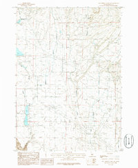
1986 Map of Hot Springs Creek Res
USGS Topo · Published 1986About this map
Hot Springs Creek Reservoir dominates the northwestern corner of this high-desert landscape in Elmore County, where a network of seasonal drainages and essential water sources define the local geography. Significant infrastructure supporting the region's utilities is evident through the numerous Trans Lines and a Pipeline that traverse the terrain, alongside a noted Pumping Station and a Radio Tower. The area's water management is further detailed by the paths of Bennett Creek, Ryegrass Creek, and Cold Springs Creek, which carve through the land towards the south. Isolated water features like Lone Tree Spring provide critical landmarks in a region otherwise characterized by its drainage basins and occasional industrial markers such as a Gravel Pit. This survey captures the technical and utility-based development of the Idaho backcountry during the mid-1980s.
Find a feature on this map
12 named features on this map. Tap any name to fly to it.
Don’t see what you’re looking for? This feature index may not catch every label — zoom into the map to look around manually.
Map Details
Editions of this 1986 Hot Springs Creek Res Map
This is the sole edition of this map. No revisions or reprints were ever made.
Other maps of this area

1892 · Mountain Home
USGS Topo · 1:125,000

1892 · Camas Prairie
USGS Topo · 1:125,000

1893 · Mountain Home
USGS Topo · 1:125,000

1893 · Camas Prairie
USGS Topo · 1:125,000

1947 · Indian Cove
USGS Topo · 1:24,000

1947 · Hammett
USGS Topo · 1:24,000

1947 · Glenns Ferry
USGS Topo · 1:24,000

1948 · Hammett
USGS Topo · 1:24,000

1948 · Glenns Ferry
USGS Topo · 1:24,000

1948 · Indian Cove
USGS Topo · 1:24,000