
1947 Map of Hammett
USGS Topo · Published 1966About this map
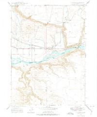
Snake River navigation and the legacy of the western migration define this landscape near the border of Elmore and Owyhee counties. The town of Hammett sits at a critical junction of infrastructure, where the Union Pacific railroad and a Short Line converge near the path of the Old Oregon Trail. This corridor represents a layers-of-history transition from 19th-century wagon routes to mid-20th-century rail and irrigation development, evidenced by the intricate Main Canal and Siphon systems drawing water to the benchlands.
Find a feature on this map
23 named features on this map. Tap any name to fly to it.
Don’t see what you’re looking for? This feature index may not catch every label — zoom into the map to look around manually.
Map Details
Editions of this 1947 Hammett Map
2 editions found
Other maps of this area

1892 · Mountain Home
USGS Topo · 1:125,000

1892 · Camas Prairie
USGS Topo · 1:125,000

1893 · Mountain Home
USGS Topo · 1:125,000

1893 · Camas Prairie
USGS Topo · 1:125,000

1947 · Indian Cove
USGS Topo · 1:24,000

1947 · Glenns Ferry
USGS Topo · 1:24,000

1948 · Hammett
USGS Topo · 1:24,000

1948 · Glenns Ferry
USGS Topo · 1:24,000

1948 · Indian Cove
USGS Topo · 1:24,000

1948 · Indian Cove
USGS Topo · 1:62,500