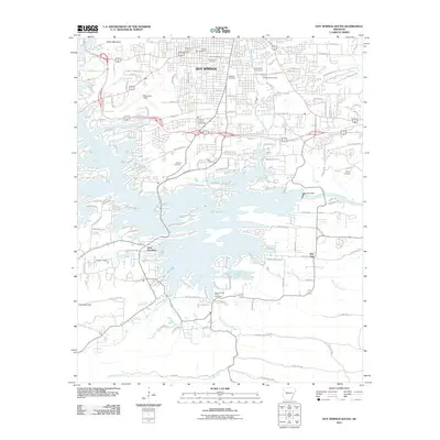
2011 Map of Hot Springs South
USGS Topo · Published 2011About this map
Lake Hamilton dominates the landscape south of the city, where the Ouachita River is harnessed by Carpenter Dam. This area reveals a transition from the urban density of Hot Springs to the intricate finger-like bays and peninsulas of the reservoir, such as Labella Bay and Hosta Bay. The map is particularly rich in genealogical data, locating numerous burial grounds including the Jewish Rest Cemetery, Calvary Cemetery, and Greenwood Cemetery clustered in the northern hills near Music Mountain. Cultural and community infrastructure is well-defined, from the Oaklawn Racetrack and Garland County Fairgrounds to the aviation hub at Memorial Field. The southern reaches are defined by a network of creeks like Mount Carmel Creek and Fourche a Loupe Creek, showing the residential expansion around the water’s edge.
Find a feature on this map
155 named features on this map. Tap any name to fly to it.
Don’t see what you’re looking for? This feature index may not catch every label — zoom into the map to look around manually.
Map Details
Editions of this 2011 Hot Springs South Map
This is the sole edition of this map. No revisions or reprints were ever made.
Other maps of this area

1890 · Benton
USGS Topo · 1:125,000

1890 · Hot Springs
USGS Topo · 1:125,000

1894 · Hot Springs
USGS Topo · 1:125,000

1894 · Benton
USGS Topo · 1:125,000

1948 · Malvern
USGS Topo · 1:62,500

1949 · Malvern
USGS Topo · 1:62,500

1955 · Little Rock
USGS Topo · 1:250,000

1956 · Little Rock
USGS Topo · 1:250,000

1960 · Little Rock
USGS Topo · 1:250,000

1964 · Little Rock
USGS Topo · 1:250,000