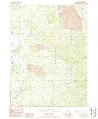
1986 Map of Hotlum
USGS Topo · Published 1986About this map
The settlement of Hotlum sits at the foot of volcanic landscapes in the mid-1980s, where the Southern Pacific railroad cuts a path through the timberlands of the Shasta National Forest. This survey captures the northern edge of Weed and its industrial layout, including Leaching Beds, a Sanitary Land Fill, and several Gravel Pits and Sandpits. The geography is dominated by distinct volcanic features like the Cinder Cone and the dramatic descent of Diller Canyon. In the southern portion of the sheet, Black Butte rises as a prominent landmark near Summit Lake and Black Butte Spring. The mapping of natural watercourses such as Graham Creek, Bolam Creek, and Beaughan Creek alongside man-made infrastructure like a Substation and Radio Facility illustrates the tension between the preserved wilderness and the requirements of the local economy during this era.
Find a feature on this map
24 named features on this map. Tap any name to fly to it.
Don’t see what you’re looking for? This feature index may not catch every label — zoom into the map to look around manually.
Map Details
Editions of this 1986 Hotlum Map
2 editions found
Other maps of this area

1886 · Shasta
USGS Topo · 1:250,000

1894 · Shasta
USGS Topo · 1:250,000

1922 · Shasta Valley Sheet No 10
USGS Topo · 1:24,000

1922 · Shasta Valley Sheet No 9
USGS Topo · 1:24,000

1934 · Macdoel
USGS Topo · 1:96,000

1935 · Dunsmuir
USGS Topo · 1:125,000

1941 · Macdoel
USGS Topo · 1:125,000

1948 · Weed
USGS Topo · 1:250,000

1950 · Weed
USGS Topo · 1:250,000

1954 · The Whaleback
USGS Topo · 1:62,500