
1973 Map of Hough NE
USGS Topo · Published 1975About this map
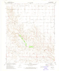
Gas exploration dominates this landscape along the border of Oklahoma and Kansas during the early 1970s. The terrain is marked by the sprawling Egahtrionsagd Gas Field, where an extensive network of wells and pipelines connects to a central Compressor Station. The map captures a moment of industrial transition, evidenced by the Old RR Grade cutting through the southwestern corner, reflecting a shift from rail-dependent transport to modern energy infrastructure. Local heritage is anchored at the Barden Memorial Cem and Camp Cem, providing fixed points of reference amidst the changing land use of the High Plains. Drainage is defined by the winding course of Pony Creek, which meanders through the southern sections of the quadrangle.
Find a feature on this map
14 named features on this map. Tap any name to fly to it.
Don’t see what you’re looking for? This feature index may not catch every label — zoom into the map to look around manually.
Map Details
Editions of this 1973 Hough NE Map
This is the sole edition of this map. No revisions or reprints were ever made.
Other maps of this area

1954 · Perryton
USGS Topo · 1:250,000

1955 · Dodge City
USGS Topo · 1:250,000

1958 · Perryton
USGS Topo · 1:250,000

1958 · Dodge City
USGS Topo · 1:250,000

1959 · Dodge City
USGS Topo · 1:250,000

1967 · Straight
USGS Topo · 1:24,000

1967 · Straight SW
USGS Topo · 1:24,000

1973 · Hough SW
USGS Topo · 1:24,000

1973 · Hough NW
USGS Topo · 1:24,000
1973 · Hough
USGS Topo · 1:24,000