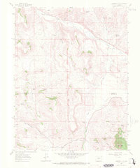
1962 Map of Houston Gulch
USGS Topo · Published 1972About this map
Parlin Flats and the surrounding high-country drainages define this 1962 landscape in the central Colorado Rockies. The map documents a sparsely populated ranching and mining region where Tomichi Creek winds through the northern flats. To the south, the terrain rises toward the Gunnison National Forest boundary, marked by prominent geological features like the volcanic profile of Lions Head and the flat-topped plateau of Table Top. Evidence of small-scale mountain industry is present at the Alaska Mine near Kettle Camp, while early agricultural infrastructure is visible via the Arch Irrigation Ditch. The network of water sources, including Prospector Spring and Valdez Spring, highlights the critical importance of water rights for established operations like Green Mesa Ranch. A decommissioned Railroad Grade serves as a reminder of earlier transportation corridors that once linked these gulches to the wider world.
Find a feature on this map
28 named features on this map. Tap any name to fly to it.
Don’t see what you’re looking for? This feature index may not catch every label — zoom into the map to look around manually.
Map Details
Editions of this 1962 Houston Gulch Map
2 editions found
Other maps of this area

1941 · Pitkin
USGS Topo · 1:62,500

1945 · Pitkin
USGS Topo · 1:62,500

1956 · Montrose
USGS Topo · 1:250,000

1959 · Montrose
USGS Topo · 1:250,000

1960 · Montrose
USGS Topo · 1:250,000

1962 · Doyleville
USGS Topo · 1:24,000

1962 · West Baldy
USGS Topo · 1:24,000

1962 · Iris
USGS Topo · 1:24,000

1962 · Houston Gulch
USGS Topo · 1:24,000

1962 · Razor Creek Dome
USGS Topo · 1:24,000