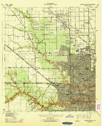
1946 Map of Houston Heights
USGS Topo · Published 1946About this map
Houston's northward expansion is clearly visible in this mid-1940s survey, showing the established grid of the Heights and the emerging residential pockets of Garden Oaks and Eureka Gardens. The landscape is a network of early suburban development intertwined with critical infrastructure, where the Southern Pacific and Missouri Kansas Texas railroads converge at Eureka Junction. The map serves as a census of mid-century community life, documenting dozens of neighborhood institutions such as the James D Burrus Sch, the George Washington Carver School, and the Heights Hospital.
Find a feature on this map
96 named features on this map. Tap any name to fly to it.
Don’t see what you’re looking for? This feature index may not catch every label — zoom into the map to look around manually.
Map Details
Editions of this 1946 Houston Heights Map
This is the sole edition of this map. No revisions or reprints were ever made.
Other maps of this area

1915 · Bellaire
USGS Topo · 1:24,000

1915 · Park Place
USGS Topo · 1:24,000

1915 · Houston Heights
USGS Topo · 1:24,000

1915 · Alief
USGS Topo · 1:24,000

1915 · Hillendahl
USGS Topo · 1:24,000

1916 · Aldine
USGS Topo · 1:24,000

1916 · Settegast
USGS Topo · 1:24,000

1916 · Satsuma
USGS Topo · 1:24,000

1916 · Humble
USGS Topo · 1:24,000

1918 · Hillendahl
USGS Topo · 1:31,680