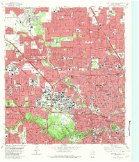
1982 Map of Houston Heights
USGS Topo · Published 1983About this map
Houston Heights stands as a primary focal point in this 1982 survey of Harris County, showing the dense residential and industrial grid northwest of the city center. The landscape is defined by the winding corridors of Buffalo Bayou and Whiteoak Bayou, which provided the natural drainage for early urban expansion. Extensive rail infrastructure is prominent, including the Eureka Yard and lines belonging to the Missouri Kansas Texas and Southern Pacific railroads, reflecting the city’s role as a major regional transit hub. For local history and genealogy research, the map provides detailed locations for numerous historic burial grounds such as Glenwood Cemetery, Woodlawn Cemetery, and Beth Israel Cem. Public institutions like the Texas Dept of Public Safety and several specialized medical facilities, including Heights Hosp and Jefferson Davis Hospital, underscore the area's development into a civic and healthcare corridor by the early 1980s.
Find a feature on this map
156 named features on this map. Tap any name to fly to it.
Don’t see what you’re looking for? This feature index may not catch every label — zoom into the map to look around manually.
Map Details
Editions of this 1982 Houston Heights Map
This is the sole edition of this map. No revisions or reprints were ever made.
Other maps of this area

1915 · Bellaire
USGS Topo · 1:24,000

1915 · Park Place
USGS Topo · 1:24,000

1915 · Houston Heights
USGS Topo · 1:24,000

1915 · Alief
USGS Topo · 1:24,000

1915 · Hillendahl
USGS Topo · 1:24,000

1916 · Aldine
USGS Topo · 1:24,000

1916 · Settegast
USGS Topo · 1:24,000

1916 · Satsuma
USGS Topo · 1:24,000

1916 · Humble
USGS Topo · 1:24,000

1918 · Hillendahl
USGS Topo · 1:31,680