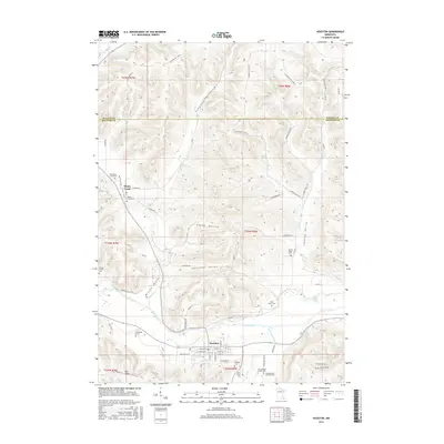
2016 Map of Houston
USGS Topo · Published 2016About this map
Root River and its S Fork Root River define the southern landscape of this region, where the town of Houston serves as a central hub. The terrain is characterized by a series of prominent valleys and hollows, including Campbell Valley, Wiscoy Valley, and Skunk Hollow, which have historically dictated the placement of roads and farmsteads. The settlement of Money Creek sits to the northwest, surrounded by several historical burial sites such as the Old Money Creek Cem and Money Creek Cem. Genealogy researchers will find an exceptional density of family and community landmarks, from the Omodt Family Cem in the west to the Looney Valley Cem in the east. The map detail highlights the transition from the upland ridges like Stinson Ridge Rd down to the fertile basins near Buell Lakes, illustrating the enduring agricultural and rural cemetery patterns of Houston County.
Find a feature on this map
70 named features on this map. Tap any name to fly to it.
Don’t see what you’re looking for? This feature index may not catch every label — zoom into the map to look around manually.
Map Details
Editions of this 2016 Houston Map
This is the sole edition of this map. No revisions or reprints were ever made.
Other maps of this area

1930 · La Crescent
USGS Topo · 1:62,500

1956 · Brownsville
USGS Topo · 1:62,500

1956 · La Crescent
USGS Topo · 1:62,500

1958 · Houston
USGS Topo · 1:62,500

1958 · La Crosse
USGS Topo · 1:250,000

1961 · La Crosse
USGS Topo · 1:250,000

1965 · La Crosse
USGS Topo · 1:250,000

1965 · Sheldon
USGS Topo · 1:24,000

1965 · Yucatan
USGS Topo · 1:24,000
1973 · Pickwick
USGS Topo · 1:24,000