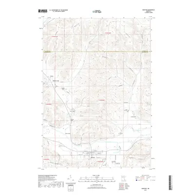
2019 Map of Houston
USGS Topo · Published 2019About this map
The Root River valley and its surrounding ridges dominate this section of Southeast Minnesota, where the township of Houston serves as a central hub near the confluence of the S Fork Root River. The landscape is defined by deep coulees and valleys like Money Creek, Looney Valley, and Wiscoy Valley, showing a pattern of settlement where farms and small communities are tucked into the sheltered lowlands. Genealogy researchers will find significant value in the distribution of family-named burial sites across the terrain, including the Omodt Family Cem, Johnstons Cem, and the Swenson and Anderson Cem. These small cemeteries, along with locations like Old Money Creek Cem and the First Swedish Baptist Cem, point to the region's diverse immigrant settlement history. The network of winding ridge roads, such as Stinson Ridge Rd, provides a clear view of how the topography has historically dictated transportation and land use in the area.
Find a feature on this map
70 named features on this map. Tap any name to fly to it.
Don’t see what you’re looking for? This feature index may not catch every label — zoom into the map to look around manually.
Map Details
Editions of this 2019 Houston Map
This is the sole edition of this map. No revisions or reprints were ever made.
Other maps of this area

1930 · La Crescent
USGS Topo · 1:62,500

1956 · Brownsville
USGS Topo · 1:62,500

1956 · La Crescent
USGS Topo · 1:62,500

1958 · Houston
USGS Topo · 1:62,500

1958 · La Crosse
USGS Topo · 1:250,000

1961 · La Crosse
USGS Topo · 1:250,000

1965 · La Crosse
USGS Topo · 1:250,000

1965 · Sheldon
USGS Topo · 1:24,000

1965 · Yucatan
USGS Topo · 1:24,000
1973 · Pickwick
USGS Topo · 1:24,000