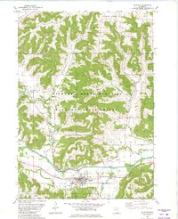
1980 Map of Houston
USGS Topo · Published 1980About this map
The Root River valley serves as the central artery for this southeastern Minnesota landscape, where the town of Houston sits at the confluence with the South Fork Root River. The river's path is shadowed by the rail line of the Chicago Milwaukee St Paul and Pacific, illustrating the historic dependence of these valley settlements on the rail-and-water corridor. Much of the surrounding high ground and steep coulees are managed as part of the Richard J Dorer Memorial Hardwood State Forest, preserving the wooded character of the Yucatan Oak Ridge and Pleasant Hill uplands.
Find a feature on this map
39 named features on this map. Tap any name to fly to it.
Don’t see what you’re looking for? This feature index may not catch every label — zoom into the map to look around manually.
Map Details
Editions of this 1980 Houston Map
This is the sole edition of this map. No revisions or reprints were ever made.
Other maps of this area

1930 · La Crescent
USGS Topo · 1:62,500

1956 · Brownsville
USGS Topo · 1:62,500

1956 · La Crescent
USGS Topo · 1:62,500

1958 · Houston
USGS Topo · 1:62,500

1958 · La Crosse
USGS Topo · 1:250,000

1961 · La Crosse
USGS Topo · 1:250,000

1965 · La Crosse
USGS Topo · 1:250,000

1965 · Sheldon
USGS Topo · 1:24,000

1965 · Yucatan
USGS Topo · 1:24,000
1973 · Pickwick
USGS Topo · 1:24,000