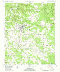
1951 Map of Houston
USGS Topo · Published 1981About this map
Houston, the county seat, sits at the heart of this mid-century Missouri landscape, where the town's street grid meets the winding course of the Big Piney River. The map reveals a community organized around rural infrastructure, featuring landmarks like the Houston Memorial Landing Field and the local Golf Course. Settlement patterns follow the terrain, with small clusters of activity marked by institutions such as Central Ch and the County Farm Cem.
Find a feature on this map
42 named features on this map. Tap any name to fly to it.
Don’t see what you’re looking for? This feature index may not catch every label — zoom into the map to look around manually.
Map Details
Editions of this 1951 Houston Map
4 editions found
Other maps of this area

1941 · Bado
USGS Topo · 1:62,500

1943 · Bado
USGS Topo · 1:62,500

1945 · Clear Springs
USGS Topo · 1:62,500

1948 · Clear Springs
USGS Topo · 1:62,500

1949 · Rolla
USGS Topo · 1:250,000

1951 · Licking
USGS Topo · 1:24,000

1951 · Raymondville
USGS Topo · 1:24,000

1951 · Prescott
USGS Topo · 1:24,000

1951 · Houston
USGS Topo · 1:24,000

1951 · Cabool NE
USGS Topo · 1:24,000