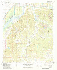
1982 Map of Howard
USGS Topo · Published 1982About this map
The Hillside National Wildlife Refuge dominates the northwestern edge of this Holmes County survey, where the Fannegusha Creek floodplain meets the steep, dissected uplands. This 1982 map illustrates a landscape of rural clusters and agricultural work sites, including several Gravel Pits carved into the hills. Transportation patterns are defined by the transition from the lowlands to the higher ground of Rankin Hill, marked by an abandoned corridor labeled as an Old Railroad Grade near the settlement of Howard.
Find a feature on this map
32 named features on this map. Tap any name to fly to it.
Don’t see what you’re looking for? This feature index may not catch every label — zoom into the map to look around manually.
Map Details
Editions of this 1982 Howard Map
This is the sole edition of this map. No revisions or reprints were ever made.
Other maps of this area

1940 · Lexington
USGS Topo · 1:62,500

1940 · Mileston
USGS Topo · 1:62,500

1953 · Greenwood
USGS Topo · 1:250,000

1954 · Mileston
USGS Topo · 1:62,500

1955 · Jackson
USGS Topo · 1:250,000

1956 · Greenwood
USGS Topo · 1:250,000

1957 · Lexington
USGS Topo · 1:62,500

1958 · Lexington
USGS Topo · 1:62,500

1961 · Jackson
USGS Topo · 1:250,000

1961 · Valley
USGS Topo · 1:62,500