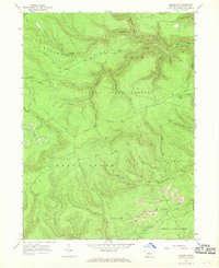
1967 Map of Howard NW
USGS Topo · Published 1968About this map
Sproul State Forest dominates this mid-1960s landscape, illustrating the rugged timber and mining character of Clinton County. Significant industrial activity is evident in the southeast near Bear Swamp, where several Strip Mines are located along the hillsides. The complex drainage network of the West Branch Susquehanna watershed is well-defined by Clendenin Run and Baker Run in the north, while Beech Creek cuts through the southwestern corner. Historically used by timbermen and early settlers, the remote interior is accessed primarily by Eagleton Road and numerous trails. Clearings such as Eagleton Fields provide evidence of early agricultural attempts or logging staging areas within the deep forest. The map captures the transition of the land from raw extraction toward managed conservation under the state forest system.
Find a feature on this map
39 named features on this map. Tap any name to fly to it.
Don’t see what you’re looking for? This feature index may not catch every label — zoom into the map to look around manually.
Map Details
Editions of this 1967 Howard NW Map
Other maps of this area

1921 · Howard
USGS Topo · 1:48,000

1923 · Howard
USGS Topo · 1:62,500

1928 · Snow Shoe
USGS Topo · 1:48,000

1931 · Show Shoe
USGS Topo · 1:62,500

1943 · Hyner
USGS Topo · 1:62,500

1946 · Renovo East
USGS Topo · 1:62,500

1946 · Renovo West
USGS Topo · 1:62,500

1946 · Renovo East
USGS Topo · 1:24,000

1946 · Renovo West
USGS Topo · 1:24,000

1946 · Glen Union
USGS Topo · 1:24,000
Featured Places
- Beech Creek Township, PA
- Bald Eagle Township, PA
- Noyes Township, PA
- Eagleton Fields, Grugan Township
- Grugan Township, PA