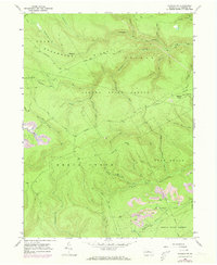
1967 Map of Howard NW
USGS Topo · Published 1973About this map
Sproul State Forest defines the rugged topography of this Pennsylvania landscape, where extractive industry and wilderness coexist during the late 1960s. The map reveals extensive Strip Mines in the southeast corner near Tangascootack Creek, a stark contrast to the dense drainage network of Beech Creek and Baker Run that carves through Shoemaker Ridge and Grugan. High-elevation clearings like Eagleton Fields suggest a history of upland activity, connected by primitive routes such as Eagleton Road and the ominous Slaughtering Ground trail.
Find a feature on this map
52 named features on this map. Tap any name to fly to it.
Don’t see what you’re looking for? This feature index may not catch every label — zoom into the map to look around manually.
Map Details
Editions of this 1967 Howard NW Map
Other maps of this area

1921 · Howard
USGS Topo · 1:48,000

1923 · Howard
USGS Topo · 1:62,500

1928 · Snow Shoe
USGS Topo · 1:48,000

1931 · Show Shoe
USGS Topo · 1:62,500

1943 · Hyner
USGS Topo · 1:62,500

1946 · Renovo East
USGS Topo · 1:62,500

1946 · Renovo West
USGS Topo · 1:62,500

1946 · Renovo East
USGS Topo · 1:24,000

1946 · Renovo West
USGS Topo · 1:24,000

1946 · Glen Union
USGS Topo · 1:24,000
Featured Places
- Beech Creek Township, PA
- Bald Eagle Township, PA
- Noyes Township, PA
- Eagleton Fields, Grugan Township
- Grugan Township, PA