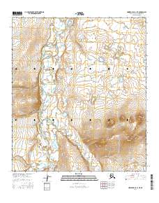
2016 Map of Howard Pass C-1 NE
USGS Topo · Published 2016About this map
The Etivluk River dominates the western portion of this Arctic landscape, carving a wide valley through the North Slope’s tundra. This drainage system serves as a primary corridor through the northern foothills of the Brooks Range, where the river braids across the valley floor. In the southern half of the quadrangle, Kutchaurak Creek (also labeled Kutchaurak Cr) flows from the eastern hills to join the Etivluk. The terrain is characterized by gradual elevation changes and small kettle lakes, typical of the glacial and permafrost-shaped topography found in this high-latitude environment. The absence of roads or permanent structures reflects the extreme isolation of this portion of the North Slope Borough, where the natural water systems remain the primary landmarks for navigation.
Find a feature on this map
7 named features on this map. Tap any name to fly to it.
Don’t see what you’re looking for? This feature index may not catch every label — zoom into the map to look around manually.
Map Details
Editions of this 2016 Howard Pass C-1 NE Map
This is the sole edition of this map. No revisions or reprints were ever made.
Other maps of this area

1951 · Howard Pass
USGS Topo · 1:250,000

1951 · Killik River
USGS Topo · 1:250,000

1956 · Howard Pass
USGS Topo · 1:250,000

1956 · Killik River
USGS Topo · 1:250,000

1984 · Howard Pass D-1
USGS Topo · 1:63,360

1984 · Howard Pass C-1
USGS Topo · 1:63,360

1984 · Killik River D-5
USGS Topo · 1:63,360
1984 · Killik River C-5
USGS Topo · 1:63,360
2016 · Howard Pass D-1 SE
USGS Topo · 1:25,000
2016 · Howard Pass D-1 SW
USGS Topo · 1:25,000