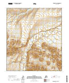
2020 Map of Howard Pass C-2 NW
USGS Topo · Published 2020About this map
The Ipnavik River carves through this remote stretch of the North Slope, serving as the primary hydrological artery in a landscape defined by its glacial and fluvial patterns. This 2020 survey captures the area's intricate drainage systems, where smaller tributaries like Cula Cr and Crassico Cr feed into the larger river basin. High-latitude topography is evident in the presence of Battery Lake, a distinctive standing water feature that provides a geographical anchor amidst the surrounding tundra. The map meticulously documents the Public Land Survey System boundaries, such as those for t8s r22w and t9s r22w, illustrating how this vast wilderness is formally organized for administrative and land management purposes by the Bureau of Land Management.
Find a feature on this map
9 named features on this map. Tap any name to fly to it.
Don’t see what you’re looking for? This feature index may not catch every label — zoom into the map to look around manually.
Map Details
Editions of this 2020 Howard Pass C-2 NW Map
This is the sole edition of this map. No revisions or reprints were ever made.
Other maps of this area

1951 · Howard Pass
USGS Topo · 1:250,000

1956 · Howard Pass
USGS Topo · 1:250,000
1984 · Howard Pass C-2
USGS Topo · 1:63,360
1984 · Howard Pass D-3
USGS Topo · 1:63,360
1984 · Howard Pass D-2
USGS Topo · 1:63,360

1984 · Howard Pass C-3
USGS Topo · 1:63,360
2016 · Howard Pass C-2 SE
USGS Topo · 1:25,000
2016 · Howard Pass D-2 SE
USGS Topo · 1:25,000
2016 · Howard Pass C-2 NE
USGS Topo · 1:25,000
2017 · Howard Pass C-3 NE
USGS Topo · 1:25,000