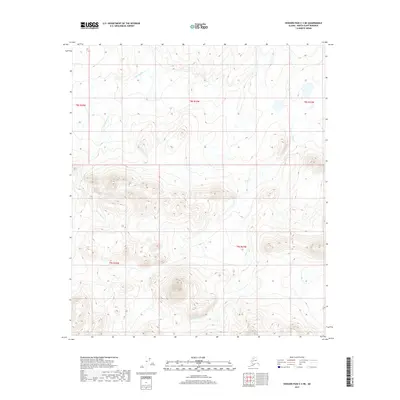
2017 Map of Howard Pass C-3 NE
USGS Topo · Published 2017About this map
Lost Temper Cr and Cula Cr define the hydrological character of this remote Arctic terrain in the North Slope Borough. This 2017 survey details the complex topography of the Howard Pass region, where the landscape is shaped by the headwaters and drainages of these small but significant waterways. The map illustrates a wilderness defined by high-elevation contours and land divisions, including portions of t8s r24w, t8s r23w, and t9s r23w. The absence of developed infrastructure or named settlements highlights the preserved natural state of this northern Alaskan environment during the early 21st century.
Find a feature on this map
7 named features on this map. Tap any name to fly to it.
Don’t see what you’re looking for? This feature index may not catch every label — zoom into the map to look around manually.
Map Details
Editions of this 2017 Howard Pass C-3 NE Map
This is the sole edition of this map. No revisions or reprints were ever made.
Other maps of this area

1951 · Howard Pass
USGS Topo · 1:250,000

1956 · Howard Pass
USGS Topo · 1:250,000
1984 · Howard Pass C-2
USGS Topo · 1:63,360
1984 · Howard Pass D-3
USGS Topo · 1:63,360
1984 · Howard Pass D-2
USGS Topo · 1:63,360

1984 · Howard Pass C-3
USGS Topo · 1:63,360
2017 · Howard Pass D-3 SE
USGS Topo · 1:25,000
2017 · Howard Pass C-3 NW
USGS Topo · 1:25,000
2017 · Howard Pass C-3 SW
USGS Topo · 1:25,000
2017 · Howard Pass D-3 SW
USGS Topo · 1:25,000