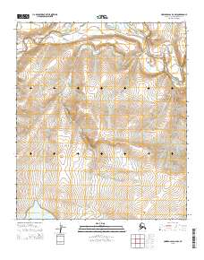
2015 Map of Howard Pass D-4 NW
USGS Topo · Published 2015About this map
The Colville River and Kiliguwa River converge in this remote Arctic landscape within the North Slope Borough, where drainage patterns define the geography. The map captures the course of Liberator Cr as it flows toward Liberator Lake in the southwestern quadrant, illustrating the delicate hydrology of the Alaskan interior. This 2015 survey provides precise topographic detail of a region devoid of permanent structures or roads, focusing instead on the natural features that serve as landmarks in the wilderness. Small tributaries like Grayling Cr feed into the larger river systems, while the township boundaries of t5s r26w and t6s r27w establish the administrative grid over this largely untouched terrain.
Find a feature on this map
9 named features on this map. Tap any name to fly to it.
Don’t see what you’re looking for? This feature index may not catch every label — zoom into the map to look around manually.
Map Details
Editions of this 2015 Howard Pass D-4 NW Map
This is the sole edition of this map. No revisions or reprints were ever made.
Other maps of this area

1951 · Lookout Ridge
USGS Topo · 1:250,000

1951 · Howard Pass
USGS Topo · 1:250,000

1956 · Lookout Ridge
USGS Topo · 1:250,000

1956 · Howard Pass
USGS Topo · 1:250,000
1984 · Howard Pass D-4
USGS Topo · 1:63,360
1984 · Howard Pass D-5
USGS Topo · 1:63,360
1984 · Lookout Ridge A-4
USGS Topo · 1:63,360
1984 · Lookout Ridge A-5
USGS Topo · 1:63,360
2015 · Lookout Ridge A-4 SW
USGS Topo · 1:25,000
2015 · Lookout Ridge A-5 SE
USGS Topo · 1:25,000