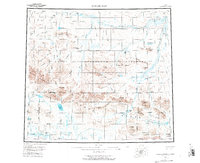
1956 Map of Howard Pass
USGS Topo · Published 1977About this map
Howard Pass serves as a critical geographic waypoint in this mid-century survey of the Arctic wilderness, where the Brooks Range meets the vast drainage basins of the North Slope. The area is dominated by the Naval Petroleum Reserve No 4, a massive federal designation reflecting the era's strategic focus on energy resources. Significant water bodies like Feniak Lake and Desperation Lake punctuate a landscape defined by the headwaters of the Colville River and the Noatak River. Topographic detail reveals the complex terrain of the De Long Mountains and distinctive features such as The Cockscomb and Rim Butte. The map also documents the convergence of the Umiat Meridian Kateel River Meridian, marking a precise moment in the systematic mapping of the Alaskan interior using photogrammetric methods from the 1950s.
Find a feature on this map
77 named features on this map. Tap any name to fly to it.
Don’t see what you’re looking for? This feature index may not catch every label — zoom into the map to look around manually.
Map Details
Editions of this 1956 Howard Pass Map
5 editions found


Other maps of this area

1951 · Baird Mountains
USGS Topo · 1:250,000

1951 · Utukok River
USGS Topo · 1:250,000

1951 · Lookout Ridge
USGS Topo · 1:250,000

1951 · Ikpikpuk River
USGS Topo · 1:250,000

1951 · Survey Pass
USGS Topo · 1:250,000

1951 · Howard Pass
USGS Topo · 1:250,000

1951 · Ambler River
USGS Topo · 1:250,000

1951 · Misheguk Mountain
USGS Topo · 1:250,000

1951 · Killik River
USGS Topo · 1:250,000

1956 · Lookout Ridge
USGS Topo · 1:250,000