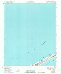
1950 Map of Howard Reef
USGS Topo · Published 1988About this map
Ocracoke Island sits at a narrow, shifting threshold between the Atlantic Ocean and the expansive Pamlico Sound. This 1950 survey, updated with 1970 aerial data, reveals a fragile coastal topography of dunes and hammocks including First Hammock Hills and Parkers Hill. While much of the area is protected as the Cape Hatteras National Seashore, the map documents human presence at Dicks Camp and Cass Williams Camp along the sound side. The landscape is defined by natural features such as Knoll Cedars and various small creeks like Knoll House Cr and Try Yard Cr that pierce the thin strip of land. To the west, the submerged Howard Reef stretches into the sound, and the northeast corner marks the critical passage at Hatteras Inlet.
Find a feature on this map
22 named features on this map. Tap any name to fly to it.
Don’t see what you’re looking for? This feature index may not catch every label — zoom into the map to look around manually.
Map Details
Editions of this 1950 Howard Reef Map
3 editions found
Other maps of this area

1948 · Portsmouth
USGS Topo · 1:24,000
1948 · Ocracoke
USGS Topo · 1:24,000

1950 · Howard Reef
USGS Topo · 1:24,000

1950 · Portsmouth
USGS Topo · 1:24,000
1950 · Green Island
USGS Topo · 1:24,000

1953 · Rocky Mount
USGS Topo · 1:250,000

1954 · Rocky Mount
USGS Topo · 1:250,000

1955 · Wanchese
USGS Topo · 1:250,000

1957 · Manteo
USGS Topo · 1:250,000

1960 · Manteo
USGS Topo · 1:250,000