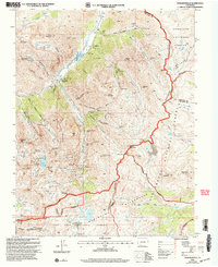
2001 Map of Howardsville
USGS Topo · Published 2005About this map
Howardsville and the high mountain valley of the Animas River define this survey of San Juan County's mining heartland. The map provides an exceptionally detailed record of the region’s industrial history, documenting a dense concentration of mineral claims and infrastructure along the Continental Divide. Prominent industrial sites include the Old Hundred Mine, the Pride of the West Mill, and the Shenandoah Mine near Cunningham Creek. The presence of the Howardsville Cem and former settlements like Middleton ground the landscape in its late 19th and early 20th-century human history.
Find a feature on this map
87 named features on this map. Tap any name to fly to it.
Don’t see what you’re looking for? This feature index may not catch every label — zoom into the map to look around manually.
Map Details
Editions of this 2001 Howardsville Map
This is the sole edition of this map. No revisions or reprints were ever made.
Other maps of this area

1897 · Silverton
USGS Topo · 1:62,500

1900 · Needle Mountains
USGS Topo · 1:62,500

1901 · Silverton
USGS Topo · 1:62,500

1902 · Needle Mountains
USGS Topo · 1:62,500

1902 · Silverton
USGS Topo · 1:62,500

1905 · San Cristobal
USGS Topo · 1:125,000

1907 · San Cristobal
USGS Topo · 1:125,000

1945 · Durango
USGS Topo · 1:250,000

1953 · Durango
USGS Topo · 1:250,000

1954 · Durango
USGS Topo · 1:250,000