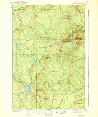
1939 Map of Howe Brook
USGS Topo · Published 1939About this map
St. Croix Lake and the Howe Brook settlement serve as the primary hubs in this remote portion of Aroostook County during the mid-1930s. The landscape is defined by a dense network of logging camps and hunting retreats, including Old Klondike Camp, Broads Camp, and the Mineola Hunting Club, indicating an economy deeply rooted in timber and outdoor recreation. The Bangor and Aroostook railroad cuts through the southwestern corner, providing essential transport for the small communities of Saunders, Little Canada, and Weeksboro.
Find a feature on this map
74 named features on this map. Tap any name to fly to it.
Don’t see what you’re looking for? This feature index may not catch every label — zoom into the map to look around manually.
Map Details
Editions of this 1939 Howe Brook Map
3 editions found
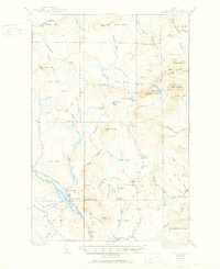
Other maps of this area

1931 · Ashland
USGS Topo · 1:48,000

1934 · Bridgewater
USGS Topo · 1:48,000

1934 · Ashland
USGS Topo · 1:62,500

1935 · Howe Brook
USGS Topo · 1:48,000

1935 · Presque Isle
USGS Topo · 1:62,500

1936 · Mars Hill
USGS Topo · 1:48,000

1937 · Smyrna Mills
USGS Topo · 1:62,500

1938 · Bridgewater
USGS Topo · 1:62,500

1938 · Houlton
USGS Topo · 1:62,500

1939 · Howe Brook
USGS Topo · 1:62,500
Featured Places
- Hammond, ME
- Howe Brook, Saint Croix Township
- Little Canada, Saint Croix Township
- Weeksboro, Dudley Township
- E Township, ME