
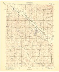
1915 Map of Howe
USGS Topo · Published 1915About this map
Auburn and its neighboring districts of North Auburn and South Auburn anchor this southeast Nebraska landscape during a period of established rail transport and agricultural settlement. The confluence of the Missouri Pacific and the Chicago Burlington and Quincy railroads created a vital shipping corridor through the Little Nemaha River valley, supporting small hubs like Brock, Johnson, and Howe.
Find a feature on this map
74 named features on this map. Tap any name to fly to it.
Don’t see what you’re looking for? This feature index may not catch every label — zoom into the map to look around manually.
Map Details
Editions of this 1915 Howe Map
2 editions found
Other maps of this area

1903 · Weeping Water
USGS Topo · 1:125,000

1907 · Nebraska City
USGS Topo · 1:62,500

1915 · Falls City
USGS Topo · 1:62,500

1915 · Nemaha
USGS Topo · 1:62,500

1916 · Humboldt
USGS Topo · 1:62,500

1929 · Weeping Water
USGS Topo · 1:125,000

1939 · Hamburg
USGS Topo · 1:62,500

1939 · Nemaha
USGS Topo · 1:62,500

1941 · Hamburg
USGS Topo · 1:62,500

1949 · Nemaha
USGS Topo · 1:62,500